New Delhi neighborhood map
You can find on this page the New Delhi neighborhood map to print and to download in PDF. The New Delhi districts map presents quarters, region, suburbs and surrounding area of New Delhi in India.
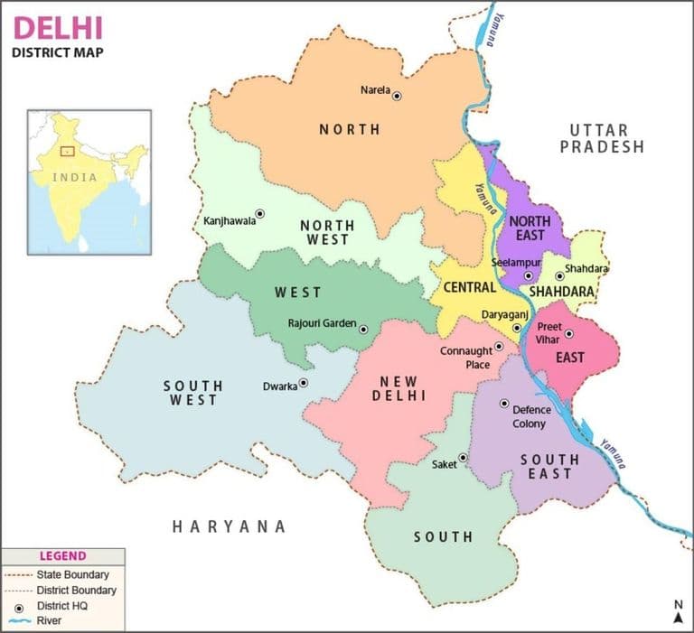
New Delhi districts map
The New Delhi districts map shows all quarters and suburbs of New Delhi. This district map of New Delhi will allow you to discover areas and the region of New Delhi in India. The New Delhi districts map is downloadable in PDF, printable and free.
The National Capital Territory of Delhi is divided into nine revenue districts as its shown in New Delhi districts map. Each district is headed by a Deputy Commissioner and has three subdivisions. A Subdivision Magistrate heads each subdivision. All Deputy Commissioners report to the Divisional Commissioner. These district are meant only for revenue collection & Administration. Delhi being a National Capital Territory of India, does not hold power to declare districts in its premises. The nine districts came into existence from January 1997. Prior to that, there used to be only one district for whole of Delhi with district head quarter at Tis-Hazari. The District Administration of Delhi is the enforcement department for all kinds of Government of Delhi and Central Government policies and supervisory powers over numerous other functionaries of the Government. is an administrative district of the National Capital Territory of Delhi in India. North West Delhi is bounded by the Yamuna River on the northeast, and by the districts of North Delhi to the east and southeast, West Delhi to the south, Jhajjar District of Haryana state to the west, Sonipat District of Haryana to the northwest and north , and Ghaziabad District of Uttar Pradesh state to the northeast across the Yamuna.